
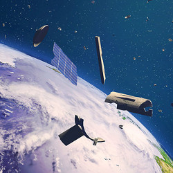
On Earth, avoiding collisions is a key priority for traffic cops, air traffic controllers, and the parents of toddlers. It is no different in space—and perhaps even more critical—given that objects orbiting the Earth are moving at more than 17,000 m.p.h., which means that even very small objects less than a centimeter in diameter have caused damage to the International Space Station, the Space Shuttle, and satellites.
In fact, the U.S. National Aeronautics and Space Administration (NASA) estimates there are more than 500,000 such objects orbiting the Earth that are larger than a marble, and at least a million smaller pieces of debris that cannot be tracked. Based on the growing number of commercial and government launches of spacecraft, satellites, and even space stations, the number of objects that will need to be catalogued, tracked, and managed is expected to grow significantly in the coming years. And the solutions to this issue are fraught with both technical and political challenges.
A key organization charged with tracking and notifying the operators of space objects of a potential course collision is the 18th Space Control Squadron (SPCS), part of the U.S. Air Force’s Space Surveillance Network (SSN), which currently tracks 27,000 objects in low Earth orbit (up to 2,000km above the Earth’s surface), medium Earth orbit (2,000km to 3,600km up), and geosynchronous equatorial orbit (located 35,786km above the Earth).
The 18th SPCS is co-located with the Combined Space Operations Center at Vandenberg Air Force Base in Santa Barbara County, CA, and is charged with handling conjunction assessments (the close physical encounters of two tracked objects in space), collision avoidance, and reentry assessment for satellites and other objects returning to Earth from space.
Object tracking is handled via a network of sensors and telescopes located around the world and in space, and utilizes two-line element (TLE) position datasets (which incorporate the parameters required to uniquely identify an orbiting element at a given point in time), which can then be fed into models that take into account atmospheric drag, gravitational drag caused by the Earth’s shape, the Earth’s spin, and various other factors in order to predict the motion of each orbiting object over time.
The Space Surveillance Network also incorporates the Haystack Ultrawideband Satellite Imaging Radar (HUSIR), which is located in the Lincoln Laboratory of the Massachusetts Institute of Technology (MIT). HUSIR, the highest-resolution, longest-range sensor in the world, simultaneously generates X- and W-band images that can provide valuable information about the size, shape, and orientation of Earth orbiting objects. HUSIR was incorporated into the SSN in 2014.
In March 2020, additional object tracking capability known as the Space Fence, designed to provide higher resolution for tracked objects, was declared operational. Located on Kwajalein Island in the Republic of the Marshall Islands near the Equator in the Pacific Ocean, the Space Fence uses an S-band radar system to track objects primarily in low Earth orbit (though it is also capable of tracking objects in higher orbits), and allows the tracking of objects below the previous size limitation of 10cm.
While the Space Fence technology permits greater visibility of smaller objects orbiting the Earth, it requires a significant amount of compute power to project the paths of these objects, according to Mike Gruntman, a professor of Astronautics at the University of Southern California’s School of Engineering.
“When the number of catalogued objects increases by a factor of four, you need an increase in computational power by a factor of 16,” Gruntman says, noting that commercial operators increasingly are launching a greater number of objects into space, and they’re not necessarily building them to a high standard of reliability, due to cost. This can create a situation where satellites malfunction, and then either fall out of orbit back to Earth, or are no longer able to be maneuvered, increasing the risk of a collision with another object in space. “So, we’ll have many more satellites presenting a challenge for many decades, until we figure out how to manage it, and the management is not easy because you cannot tell a certain country, ‘you cannot launch a satellite.'”
Gruntman adds that simply adding more compute power, while helpful, is not yet able to overcome the accuracy constraints of existing sensors which cannot account for atmospheric drag and solar radiation, introducing a high degree of variability in an orbiting object’s path, as well as the time and trajectory of an object that is expected to fall out of orbit and return to earth. Ultimately, “more frequent observations by multiple sites will help to continuously correct the predictions,” according to Gruntman. However, he adds that no amount of compute power can address the increasing number of owner/operators who launch objects into space, but choose not to report or share their trajectories to tracking authorities.
This is exacerbated by the lack of a single overriding international authority that would serve as space’s equivalent of air traffic control. While the United Nations Office for Outer Space Affairs (UNOOSA) promotes international cooperation in outer space, it does not have any recognized authority to enforce regulations at the international level.
Within the U.S., a 2018 White House directive appointed the Commerce Department to serve as the traffic cop for space, though other agencies are likely to continue to have some role in the management of space traffic. The Federal Aviation Administration (FAA) regulates launches and reentries, and the Federal Communications Commission (FCC) is responsible for regulating satellite transmissions.
The U.S. Department of Defense, meanwhile, perhaps has the most active role in tracking and managing objects in orbit through the 18th SPCS, though it relies heavily on cooperation between parties, including other space authorities such as NASA, the European Space Agency, and Russia’s Roscosmos State Corporation for Space Activities, as well as cooperating with commercial space companies, rather than specific inter-country or worldwide authorities.
“The 18th Space Control Squadron provides collision avoidance services, which is a free service provided to satellite owner/operators on behalf of the United States Government through the United States Space Command,” explains Lt. Col. Justin Sorice, the commander of the 18th SPCS. “The 18th Space Control Squadron sent out almost 20 million conjunction data messages this year, informing satellite owner/operators how close their systems are approaching other space objects in order to make a maneuver decision.”
The 18th SPCS currently shares Space Domain Awareness information with more than 100 governmental, academic, and commercial partner organizations from 25 nations through formal Space Situational Awareness data-sharing agreements, and via a publicly accessible website, www.Space-Track.org. It is this data sharing and cooperation that is enabling U.S. government agencies tasked with tracking objects to work with foreign governments and commercial operators to identify and track satellites, rockets, and other items being launched into space.
“One of the most valuable things we can do is what we call early engagement, making contact with new owner-operators, whether they’re commercial, civil, or whatnot, and really understanding what their mission objectives are,” says Diana McKissock, SSA Sharing & Spaceflight Safety Lead for the 18th SPCS. “The DoD does not have the authority to manage space traffic; rather, we provide spaceflight safety data that helps satellite owners/operators make responsible decisions to mitigate risk to their spacecraft and the space environment. A significant challenge for the space community is the lack of agreed-upon norms of behavior or enforceable global regulations, which could provide a true space traffic management construct.”
Communication and cooperation with commercial and government owner-operators of space objects will be key to limiting future space collisions between objects, given the growing number of conjunctions each year. “In 2019, there were about 328 close conjunctions with the International Space Station (ISS),” Sorice said, adding that during 2020 through the end of November, “we’ve had 460. So again, the space domain is becoming a lot more congested as we go forward.”
McKissock says for objects in low Earth orbit, emergency reportable criteria, which allows the 18th SPCS to share information with the owner or operator of any active satellite, specifies the time of closest approach between two objects within a 72-hour period, with a miss distance of one meter, and a probability of collision of greater than 1 in 10,000. The criteria for deeper orbits expands the miss distance to less than 500 meters. In the absence of an international space regulator, cooperation between commercial and government operators is key to eliminating potentially catastrophic collisions.
“The policies that we work under allow us to share information with the owners and operators of any active satellite, which allows us to work closely with a lot of foreign civil and commercial entities who are willing to communicate with us,” McKissock says. “Right now, of the nearly 3,500 active satellites, I think we have positive communication with about 95% of those owner-operators.”
“One of the most valuable things we can do is what we call early engagement, making contact with new owner-operators … and really understanding what their mission objectives are.”
The desire to reduce or eliminate collisions cannot be overstated. While there is being work done to improve the accuracy of calculating the physical impact of objects colliding in space, Gruntman says that experimental databases are limited, and major uncertainties are likely to remain because in the event of a collision between a piece of space debris and a satellite or spacecraft, “the debris/fragment field significantly depends on the design of particular spacecraft.” McKissock adds that while increasing the available compute power also may aid in predicting where and when satellites may return to Earth, “having accurate information on the reentering spacecraft, as well as a reliable atmospheric density model, are also key contributors to accurate reentry predictions.”
To assist in the analyses of the potential conjunctions of such a large (and growing) number of objects, the 18th SPCS increasingly is deploying machine learning technology to automate the tracking of objects, as well as the prediction of conjunctions between objects, so conjunction assessments can be managed without overwhelming human resources. Orbital altitude, speed, and course trajectory data from satellites and other objects orbiting the Earth (or falling out of orbit) are fed into an algorithm that can learn and predict future close conjunctions.
However, it is not just governmental agencies that may play a role in managing space traffic. Canadian company NorthStar Earth & Space is planning to launch a constellation of 12 satellites equipped with optical sensors to monitor space objects in low Earth orbit, with the initial launch of three satellites next year, and the remainder by 2024. The company likely will use a subscription-based revenue model, charging organizations to access traffic and collision data. However, as it is a commercial entity, it is unlikely any operator that did not wish to move its equipment in orbit could be compelled to do so.
Still, the biggest issue for any organization tracking objects in space is not managing active satellites or equipment in orbit; there’s no benefit to having something smashed to bits if it’s at all possible to reposition a satellite or space station. Space debris or junk that cannot be controlled is the primary concern, given the potential chain-reaction of a collision, Sorice says.
“When we’re talking about thousands of pieces of debris moving at 17,000 miles per hour and potentially creating chain effects within that orbital regime, that’s what keeps me up at night, and making sure that we do our best to prevent this scenario,” Sorice says. “Because those pieces of debris don’t have political agendas, they’re just simply following the laws of physics at that point in time. You need to keep up calculational power to be able to predict where those pieces may be going, and what assets are at threat.”
 Further Reading
Space Debris and Human Spacecraft, National Aeronautics and Space Administration, Sept. 26, 2013, https://www.nasa.gov/mission_pages/station/news/orbital_debris.html
Real-time object tracking data www.Space-track.org
The Truth About Space Debris, Real Engineering, https://www.youtube.com/watch?v=itdYS9XF4a0

Join the Discussion (0)
Become a Member or Sign In to Post a Comment