
When Kenyans went to the polls in late 2007, the voting results were disputed, and ethnically aligned gangs slaughtered more than 1,100 people during weeks of violent unrest. A national media blackout followed.
Within days, an ad hoc group of Kenyan bloggers and software developers created the first instantiation of the Ushahidi (“testimony” in Swahili) platform, enabling people to share instant reports of violent incidents—via video, audio, photos, texts, SMS, emails, Twitter, and Web forms—and to visualize them on a real-time online map, to keep communities informed of the danger.
Just two years later, when a catastrophic magnitude 7.0 earthquake struck Haiti in 2010, Ushahidi sprung to prominence as a key player in what has become a growing field of information and communication technologies (ICTs)—so-called “peace technologies.” Deciding to put its real-time maps to good use once again, Ushahidi had a local Haitian radio station broadcast a free telephone number that forwarded texts to a group of volunteer graduate students working in a basement at Tufts University’s Fletcher School in Boston.
By the time the Red Cross and others arrived on the scene in Haiti, an Ushahidi crisis map was available, online, and ready to guide rescue workers to red-dot locations from where there had come cries for help. In fact, U.S. Federal Emergency Management Agency (FEMA) chief Craig Fugate tweeted that the Ushahidi map of Haiti “was the most comprehensive and up-to-date map available to the humanitarian community.” Then-U.S. Secretary of State Hillary Clinton, in a 2010 speech on Internet freedom, credited the map with leading a U.S. team to a seven-year-old girl and two women who had been buried under the rubble of a collapsed Haitian supermarket.
The Ushahidi platform itself has been described as a mash-up of SMS, email, and Google Earth, plus OpenStreetMap. To make sense of all the information that is being accumulated, a platform called SwiftRiver was later developed to enable the filtering and verification of real-time data.
In a mere five years, the Ushahidi platform has been deployed in more than 159 countries, and has been translated into more than 35 languages. Despite its roots in election monitoring, Ushahidi’s software has been used for crisis response in Haiti, Pakistan, Chile, Indonesia, the Czech Republic, the U.S., and elsewhere, and for civil society actions having to do with the environment, harassment, and anti-corruption.
“We have seen a shift by governments and international bodies toward actively asking citizens to report incidents of violence in potential flashpoint situations, such as elections,” observes Catherine Dempsey, a Ph.D. candidate at King’s College London’s Department of War Studies, who currently is researching community-led initiatives to prevent conflict using ICTs.
During the run-up to a constitutional referendum in 2010, the Kenyan government’s National Steering Committee on Conflict Management and Peacebuilding asked citizens to report to an Ushahidi-inspired social media violence monitoring platform—the Uwiano Platform for Peace.
Ushahidi also set up an extensive election monitoring and violence monitoring project—called Uchaguzi—for the presidential elections in Kenya last March. The organization brought on board and trained more than 200 volunteers to work on the project, and partnered with state institutions and law enforcement as responders to emergency reports.
The use of Ushahidi has become so pervasive that a wiki now tracks “deployments of the week.”
In fact, the use of Ushahidi has become so pervasive that a wiki now tracks “deployments of the week,” which range in diversity from mapping Hurricane Sandy to keeping count of the world’s mangroves to following the Palestinian crisis.
“Ushahidi is free and open-source software used for interactive mapping, data visualization, and information collection,” explains Heather Leson, director of community engagement at Ushahidi, now a non-profit tech company. “Anyone can download the software or set up a map project. Maps have always been storytelling devices, but Ushahidi provides our users the opportunity to build the community network, customize, add layers of data, and even import/export content. With our code on GitHub, our community has created plugins, or simply forked the code to create their own projects.”
Funding for Ushahidi’s efforts comes from a potpourri of organizations; these include the Ford Foundation, the United States Institute of Peace (USIP) Center of Innovation for Science and Technology, the Omidyar Network, the Knight Foundation, the MacArthur Foundation, Google, the Mozilla Foundation, the Cisco Foundation, and others.
By enabling anyone to share geolocated information in real time, Ushahidi provides situational awareness for local communities, says Dempsey. She cites several examples of projects that are using Ushahidi technology for conflict prevention:
- SyriaTracker. Maps reports of violence in Syria’s civil war, serving as one of the most comprehensive sources of information on the conflict.
- LERN. Liberia’s Early Warning and Response Network maps incidents of violence across Liberia.
- Women Under Siege Syria. A Women’s Media Center project to map incidents of sexualized violence in Syria.
- Harassmap. Uses Ushahidi to map and challenge the social acceptability of sexual harassment in Egypt.
While Ushahidi is probably the best-known peace technology, says Dempsey, there are quite a few other groups and organizations working in this field. These include:
- FrontlineSMS—A free and open-source text-messaging software to connect communities using SMS.
- Humanitarian OpenStreetMap Team (H.O.T)—A project to connect the OpenStreetMap community with traditional humanitarian responders.
- CrisisTracker—A software platform that extracts situational awareness from torrents of public tweets during humanitarian disasters, combining automated processing with crowdsourcing to detect events and collate evidence.
- Standby Task Force (SBTF)—A volunteer community providing dedicated crowdsourcing, mapping, data scrambling, and technology testing support to local and international humanitarian and human rights organizations.
“Conflict prevention and peace-building work is so often about developing communication and information awareness,” says Dempsey, “so new communication tools of all kinds are increasingly being used for these purposes.”
She cites a group of civilians in Kyrgyzstan who carried out real-time fact-checking through a Skype chat group to debunk dangerous rumors that were fueling violent conflict in June 2010. In addition, an organization called Peace Provocateurs used Facebook and Twitter to correct mainstream media reports on clashes between Muslims and Christians in Indonesia in September 2011, helping to defuse tensions between those religious groups.
“Using technology for conflict prevention is nothing new,” says Sheldon Himelfarb, director of the USIP’s Center of Innovation for Science and Technology, which provided funding to Ushahidi during the Haitian crisis. “But what is different today—and this is the essence of Ushahidi—is that suddenly, for the first time in human history, everyone has the ability, no matter how poor you are, to send texts, data, photos, and words around the world with the push of a button. It is that phenomenon that Ushahidi captures by crowdsourcing information and allowing it to be put to use in communities who want to help themselves.”
Ultimately, what is unique about Ushahidi, Himelfarb says, is that no one controls it.
“Ushahidi is a small, not-for-profit tech company that had one of the best ideas of the 21st century for capturing information,” says Himelfarb, “and now, because it is open source and you can just go online and create an instance, people everywhere are using it. Ushahidi—or some version of it—is now being used in every single disaster around. If there is a tornado in Oklahoma, for example, I promise you there is a Ushahidi map up in about three minutes.
“Ushahidi has ushered in a whole new era of crowdsourced disaster response.”
However, not all peace technologies focus on mapping using data collected on the ground; for instance, the American Association for the Advancement of Science (AAAS) Geospatial Technologies and Human Rights Project (GTHR) depends upon the gathering and analysis of high-resolution satellite imagery instead.
“We form partnerships with human rights organizations—like Amnesty International—and use the imagery to document areas of concern, often in places that are too dangerous to send people on the ground,” says Susan Wolfinbarger, director of GTHR, which is part of the Scientific Responsibility, Human Rights, and Law Program of AAAS, an organization that also publishes the journal Science.
The GTHR recently released its report on Aleppo, Syria, where it used satellite imagery to document craters, destroyed buildings, destruction of cultural artifacts, and numerous roadblocks. Other GTHR projects include the documentation of the destruction of villages in Darfur, Sudan, and grave sites and the bombing of civilian shelters after the intense fighting in Sri Lanka in 2009.
“Ours is just one of the many ways that peace technologies are entering into the work of human rights groups,” Wolfinbarger says, “the others being early warning systems, databases, the use of disruptive technologies for communications, disaster response, Internet privacy mechanisms, and so on.”
Ushahidi, too, is working on new technologies, including BRCK, its first foray into hardware. Earlier this year, the organization launched a Kickstarter campaign to build a backup generator for the Internet. The small, lightweight box that is about the size of an actual brick works like a mobile phone, seamlessly switching between Ethernet, Wi-Fi bridging, and a 3G/4G connection whenever the user’s preferred network is down. Plug in a SIM card and, with its eight-hour battery, the BRCK prototype provides a fully functioning network anywhere in reach of cellular service. Ushahidi’s developers are currently searching for a manufacturer for BRCK.
Going forward, Ushahidi’s goal is “to create free and open-source software to democratize information,” says director of community engagement Leson.
“We want to help connect citizen voices to action,” she says. “Ushahidi is now five years young. Our community and their reports are some of our biggest opportunities. We are diving into data to understand curation, signal-to-noise, and ways to use technology to assist this journey.”
Further Reading
Rahul Chandran and Andrew Thow
“Humanitarianism in the Network Age,” 2013, the United Nations Office for the Coordination of Humanitarian Affairs (OCHA), https://docs.unocha.org/sites/dms/Documents/WEB%20Humanitarianism%20in%20the%20Network%20Age%20vF%20single.pdf
Francesco Mancini (ed.)
“New Technology and the Prevention of Violence and Conflict,” April 25, 2013, the International Peace Institute, http://www.ipinst.org/media/pdf/publications/ipi_epub_new_technology_final.pdf
Heather Leson (ed.)
“Uchaguzi Kenyan Elections 2013,” April 24, 2013, Ushahidi, https://wiki.ushahidi.com/display/WIKI/Uchaguzi+-+Kenyan+Elections+2013
“Mapping Syria,” a video posted July 16, 2013 by Ushahidi, at http://www.youtube.com/watch?v=NRG0PqYisZ8
Jessica Heinzelman and Carol Waters
“Crowdsourcing Crisis Information in Disaster-Affected Haiti,” September 29, 2010, the United States Institute of Peace’s Center of Innovation for Science, Technology, and Peacebuilding, http://www.usip.org/sites/default/files/SR252%20-%20Crowdsourcing%20Crisis%20Information%20in%20Disaster-Affected%20Haiti.pdf
Jessica Heinzelman, D. Roz Sewell, Jen Ziemke, and Patrick Meier
“Lessons from Haiti and Beyond: Report from the 2010 International Conference on Crisis Mapping,” March 7, 2011, the United States institute of Peace, http://www.usip.org/sites/default/files/PB83.pdf
Jakob Rogstadius
“Introduction to CrisisTracker,” July 7, 2012, http://vimeo.com/45366518
Figures
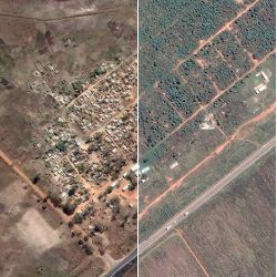
 Figure. In one of its earliest projects, Ushahidi documented the demolition of settlements in Zimbabwe that the government claimed were illegal; human rights groups felt the demolitions were politically motivated. The before (above) and after photos show how the settlement in Porta Farm, Zimbabwe, was completely erased.
 Figure. An Ushahidi smartphone app, which allows users to report incidents, as well as view incident reports.


Join the Discussion (0)
Become a Member or Sign In to Post a Comment