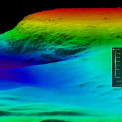
Understanding what lies beneath the surface of the sea has always been a formidable challenge. Visibility is terrible, moving around can be difficult, and the ambient pressures become deadly with depth. Although submarines and modern equipment can peer beneath the surface, the world's oceans remain mysterious places that haven't been fully explored.
That is beginning to change, however. Autonomous underwater vehicles (AUVs)—more commonly referred to as underwater drones—are quietly reshaping oceanographic research and various underwater tasks. "These robotic systems allow researchers to gather data in ways that were difficult or impossible in the past. They are force multipliers," says Vicki Ferrini, a research scientist at the Lamont-Doherty Earth Observatory at Columbia University.
Equipped with a growing array of sensors, sophisticated propulsion systems, and advanced software, underwater drones are helping researchers map the sea floor, understand currents, view dead zones, conduct fish counts, improve tsunami prediction, and more. They also are aiding in finding shipwrecks, building windfarms, and accomplishing tasks including inspecting deep sea oil platforms and nuclear reactors in vessels.
"These autonomous systems deliver a far more complete picture of the underwater world," says Nathan Michael, director of Carnegie Mellon University's Resilient Intelligent Systems Lab (RIS Lab).
Sea Change
Make no mistake, robotic technology is reinventing underwater exploration. Only about 15% of the world's oceans have been mapped at a resolution of 100 meters—and even most of these areas remain largely unexplored. "Underwater drones provide continuous data about the sea floor and they deliver far greater resolution than we've had in the past," Ferrini says.
Equipped with various sensors—including sonar, lidar, radar, infrared, temperature, chemical detection and more—it's possible for an underwater drone to peer into an environment and collect data at double or triple the rate possible in the past—and collect higher-quality data. Previously, researchers had to lug around bulky multi-beam sonar systems and take manual readings as a ship moved through the water. These systems are expensive, bulky, slow, and prone to errors.
Already, autonomous underwater drones are making their mark. A high-profile example is Seabed 2030, a joint effort of two nonprofit organizations that aims to map the entire ocean floor in just over a decade. It relies on drones operated by numerous groups to gather data, which may be fed into machine learning systems. The project, since it launched in 2017, has already increased the percentage of the total seabed that has been surveyed from about 6% to more than 15%.
"The first step in better protecting the oceans is to have a better understanding of them," says Rochelle Wigley, project director for the Nippon Foundation GEBCO Project Center for Coastal and Ocean Mapping/Joint Hydrographic Center of the University of New Hampshire.
Beneath the Surface
Underwater drones come in an array of shapes, sizes, and designs. They range from units about a meter long to vehicles the size of small boats, and they can cost anywhere from thousands of dollars to $10 million or more.
Not surprisingly, size, weight, and power considerations are critical elements in designing and using these systems. More sensors and longer periods underwater require larger batteries. The most advanced underwater drones, such as those built by the Norwegian firm Kongsberg Maritime AS, can dive to more than 6,000 meters and stay underwater for approximately 72 hours.
Because underwater drones can't communicate as freely with the cloud and other computing systems for extended periods, on-board navigation and programming is critical, Michael says. "These systems require a great deal of robotic perception in order to have the level of underwater autonomy needed." The type and positioning of the sensors is critical for navigation when GPS and communications networks are not available. Drones also require specialized programming to find wrecks, spot specific types of sea life, and accomplish other specialized tasks.
Wigley says internal programming is a critical issue, and researchers are constantly looking for ways to build better algorithms, software models, and avoidance systems. Ferrini believes further advances in computing power, improved battery systems, and more advanced sensors will unlock many of the secrets of oceans, deep water lakes, and other underwater areas.
The use of these drones will undoubtedly grow in the coming years. In July, an underwater drone found the French submarine Minerve, which vanished off the coast the Southern Coast of France in 1968. The wreckage was discovered at a depth of nearly 2,500 meters, or 1.5 miles. The U.S. Navy has also developed autonomous underwater vehicles that it plans to use for a variety of purposes, including the waging of war.
Concludes Ferrini, "We're at a turning point where the on-board intelligence, sensing, navigation, and software programming are allowing underwater drones to tackle sophisticated tasks."
Samuel Greengard is an author and journalist based in West Linn, OR, USA.


Join the Discussion (0)
Become a Member or Sign In to Post a Comment