Traditionally, the Internet has been viewed as a collection of more or less stationary machines wired to a network. But with the popularity of smartphones and their embedded sensors—a camera, a microphone, an accelerometer to determine the phone’s orientation, and a global positioning system (GPS) locator—the power of computing is spreading beyond the desktop. Last year an executive from telecom giant Ericsson predicted that 50 billion devices will be connected by 2020, leading to an “Internet of things” in which everyday objects become part of the network, gathering new types of data and creating possibilities that didn’t previously exist.
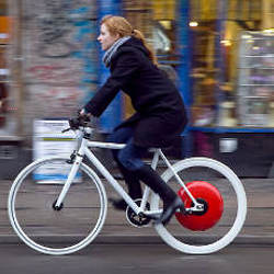
One activity where the Internet may soon tie into non-cyberspace life is the world of cycling. The Copenhagen Wheel, a project of the SENSEable City Lab, part of the Department of Urban Studies and Planning at the Massachusetts Institute of Technology (MIT), places environmental sensors on the rear wheel of a bicycle, providing information that could add value to the rider’s experience while also giving valuable data to city planners. Biketastic, a project of the Center for Embedded Networked Sensing at the University of California at Los Angeles, also enables cyclists to share their experiences, using just the smartphone’s microphone and accelerometer to measure route conditions. The idea is to help cyclists find the safest, most efficient, and most enjoyable routes through the metropolis.
The Copenhagen Wheel was introduced at the Copenhagen Climate Conference last December, and MIT is in talks with city officials to make it available there as part of Copenhagen’s campaign to increase bicycle commuting from about 35% to 50% of its 500,000 citizens. The Wheel, which replaces the rear wheel of a standard coaster-brake bicycle, contains a small motor and 16 lithium-polymer batteries, recharged by regenerative braking. When the rider needs a boost—because she’s climbing a steep hill, for instance—the motor kicks in to assist. When she brakes, the energy is stored in the batteries.
The hub of the wheel also contains electronics to control the motor and measure torque, and a Bluetooth connection to communicate with a smartphone. A cradle on the handlebars holds the smartphone, which runs an app that allows the rider to select one of three modes, providing extra assistance for a rider who wants to get to work without much sweat, or increasing resistance to put the rider through a workout and recharge the batteries. The rider can also switch gears through the phone.
But what makes the Wheel computationally interesting is the addition of sensors and networking, “turning a bike from something that gets you from A to B into a smart network object,” says Christine Outram, an MIT research associate who leads the project. The hub contains sensors that measure carbon monoxide, nitrogen oxides, temperature, humidity, and noise, taking readings every two seconds.
Not all that data is displayed during the ride—it could be too distracting. Generally, the smartphone will alert the rider only when she reaches a personal best or when a friend is within a designated proximity. The phone can store the data and let the user review it later.
The data can also be transmitted to a city-owned server, and Xiaoji Chen, an MIT graduate student in architecture who works with the SENSEable City Lab, has created a program that will enable city planners to visualize the data. A map displays the incoming data from each rider as a series of color-coded spikes. A viewer can watch, say, the noise level as a rider travels through the city, with older data slowly fading from view to keep the data current.
“If we have enough data, we can see how this changes over weeks or months or years,” Chen says. The data can be cross-referenced with information about land use at various points along the routes. “We can see how this pollution level is related to weather, or to policies promoting bicycles,” she says.
The data could help city planners identify urban heat islands, where an abundance of asphalt and concrete artificially raise temperatures. It could also pinpoint areas suffering from noise pollution or a concentration of exhaust fumes. By measuring the speed of bicyclists and how often they stop, the system could alert both traffic planners and cyclists to areas of traffic congestion. And measurements from the smartphone’s accelerometer could call attention to potholes or other potentially dangerous street conditions.
Copenhagen currently has three fixed environmental sensors in the city, one at street level and two about three stories high. Because there will be more of them and they will be at street level, sensors on the bikes will provide a lot more point data. It will only take about 100 cyclists equipped with the Wheel to get good coverage of a two-kilometer-square downtown area, says Outram.
Cyclists tapping into the network can also see historical data not only for their own bike routes but for those used by others. That may allow them to choose a route that is quieter or less polluted. It also lets them interact with their fellow cyclists if they choose to, meeting en route for a break or to ride together. “We’re trying to make some of the connections through Facebook or other social networking sites—these virtual connections—physical,” Outram says.
Los Angeles’ Biketastic
While European metropolises like Copenhagen tend to have compact downtowns conducive to bike riding, sprawling Los Angeles is very much geared toward cars. But biking is still popular there, and the Biketastic project aims to make it easier for Los Angelenos to find safe and pleasant routes, both for commuting and recreational rides. University of California at Los Angeles (UCLA) researchers designed an application for Android phones and conducted a two-week pilot project last fall.
Riders launch the Biketastic application when they mount their bikes, and the phone uses GPS data to trace the route and measure the cyclist’s speed. The app asks if the phone is in a bag or out in the open, so it knows whether it can use the phone’s microphone to measure noise. If the cyclist mounts the phone on the bicycle, the phone figures out its orientation and uses the accelerometer to measure road roughness. The rider can take pictures of interesting landmarks or dangers such as potholes. All the data is uploaded to a Web site, which overlays the information on Google Maps, adds information about elevation, and allows cyclists to include tags and descriptions.
About 450 cyclists have registered for the Biketastic Web site and mapped out almost 1,400 routes in Los Angeles.
Rather than design new devices, Sashank Reddy, the Ph.D. student at UCLA who headed the Biketastic project, wants to take advantage of sensors people already carry with them. “Our purpose is to understand how we can use the sensors, what are the algorithms to clean up the data, and what are appropriate visualization techniques,” he says.
About 450 users have registered for the Biketastic Web site and mapped out almost 1,400 routes. While the app is available to Android phone users, it probably takes a minimum number of people in a city to be useful, Reddy says, and he’s not focused on expanding the project, though he wouldn’t mind seeing someone else commercialize products or services based on his work. Cycling advocacy groups and city planners have asked him about how they might use his techniques, but nothing has progressed beyond the pilot stage.
Ron Milam, a consultant for planners of environmentally friendly projects and a writer about biking in Los Angeles on his BikeSage blog, participated in the pilot project and got a better sense of the speed and distances he was riding. He thinks Biketastic can be particularly useful by providing people with routes that others have discovered, and thus make it easier for people to shift from driving to cycling for some of their trips. “Having this information around could not only inspire people to ride a bike but also give them some really concrete information on places they may want to go,” Milam says. “The perception is you can’t ride a bike or walk in L.A., but the reality is more people are choosing to do that here.”
Meanwhile, Outram’s team is working on making the Copenhagen Wheel more compact, and hopes to commercialize it within the year. They plan to first sell it to cities, for use on fleets of bicycles used by police or traffic enforcement officers. In addition to Copenhagen, Los Angeles, Mexico City, Sydney, and Wellington, New Zealand have expressed interest. Once the cities get the system operating, individual cyclists would be able to start buying in.
Outram sees the Wheel as just one example of how the growing ubiquity of computing, sensing, and communication can improve both individual lives and society as a whole. “The broader vision of the lab is to ask, ‘What is the future of living with technology going to be?'” she says. “In 10 to 15 years, we’ll be able to have this ‘Internet of things.’ We want to explore possibilities about how we live with technology in a kind of human way.”
 Further Reading
Hirshberg
The Copenhagen wheel, http://www.youtube.com/watch?v=Do3lxv_ekUo
Iveson, K.
Too public or too private? The politics of privacy in the real-time city, First International Forum on the Application and Management of Personal Electronic Information, Cambridge, MA, October 1213, 2009.
Ratti, C., Pulselli, R.M., Williams, S., and Frenchman, D.
Mobile landscapes: using location data from cell phones for urban analysis, Environment and Planning B 33, 5, 2006.
Reddy, S., Shilton, K., Denisov, G., Cenizal, C., Estrin, D., and Srivastava, M.
Biketastic: sensing and mapping for better biking, ACM Conference on Human Factors in Computing Systems, Atlanta, GA, April 1015, 2010.


Join the Discussion (0)
Become a Member or Sign In to Post a Comment